
These Little Satellites Could Help Us Learn How Deadly Hurricanes Form
Unlike conventional satellites, these can gather information from the inside of a storm.
LEARN MOREWhen the GOES-16 satellite is fully operational, it will be responsible for more than just taking awesome pictures.
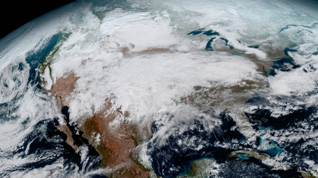
A new weather satellite took these breathtaking images of Earth, and the world is seeing them for the first time.
The National Oceanic and Atmospheric Administration satellite, which is currently called GOES-16, launched in November 2016.
It orbits more than 22,000 miles above the planet. And NOAA is pretty excited about what it's captured so far.
The agency called the images "the latest step in a new age of weather satellites. It will be like high-definition from the heavens."
Unlike conventional satellites, these can gather information from the inside of a storm.
LEARN MOREBut GOES-16 will do a whole lot more than snapping awesome pics when it's fully running.
Part of the satellite's mission is taking images of severe storms up to every 30 seconds. Those images will help NOAA make more accurate and reliable weather forecasts.
Beyond helping with weather forecasts, GOES-16 will also help make seasonal predictions, like drought outlooks, provide long-term climate data and help monitor for satellite-damaging solar flares from the sun.
A spokesperson for NOAA's satellite division says the GOES-16 won't be fully operational until November.
The Lyrids, named for the nearby constellation Lyra, have been observed for 2,700 years, according to NASA.
A piece of debris originating from the International Space Station crashed through two floors of a Florida home in March.
The couples got married at a mass wedding event in Arkansas cleverly named "Total Eclipse of the Heart."
The device from Abbott Laboratories can reportedly detect if a patient has mild traumatic brain injury in just 15 minutes.
The company said the apps were removed at the request of Chinese officials citing unspecified national security concerns.
The families held a virtual press conference on Friday, noting that it's been nearly 200 days since their loved ones were taken captive.
